
The History of Sebastian Inlet
The first settlers begin to arrive in the Sebastian River area in the mid-1800s, and by all accounts, there were numerous attempts to open a “cut” or an inlet on the barrier island from the Indian River to the Atlantic Ocean near what is present-day Sebastian Inlet. Among those settlers were two men – Reverend Thomas New and D.P. Gibson.
For many years, it was believed that Reverend Thomas New was the first to attempt a “cut” in 1881 after founding the town that would become Sebastian. A U.S. Geodetic Survey Map in the District’s historical collection that was drawn in the winter of 1880-81 shows “Gibson’s Cut” as a feature. Combined with other material evidence, we know D.P. Gibson’s attempt predated New’s and historians believe that first known attempt took place in 1872.
1905 - At least six substantiated attempts to open a “cut” were made by 1905, and all were closed by sand, storms and other natural causes almost as soon as they were opened.
Coinciding with that sixth recorded attempt in 1905, Roy O. Couch - a figure whose name is synonymous with the Sebastian Inlet - arrived in Brevard County. No other man would persevere the way Couch did to get a permanent inlet open, and though that sixth attempt was successful, as reported in the Ft. Pierce Tribune, it wasn’t long before the Inlet again filled with sand.
1909-1914 - The Indian River Lagoon’s water quality steadily declined. In 1914, a petition was circulated asking for an appropriation of $1,200 to open an inlet.. 100 signatures were gathered and a delegation of 40 individuals from southern Brevard County presented it to the Brevard County Commission at their April 1914 meeting. Roy Couch was among those who spoke in favor and was likely instrumental in putting the petition drive together. The effort didn’t lead anywhere.
1915 - The inlet was a hot topic. With northern Brevard residents against it, a plan to split the county was carried to Tallahassee to no avail. Another insurmountable problem; the U.S. Army Corps of Engineers would not issue the needed War Department permit because it objected to the idea of an inlet in Sebastian. They were obliged to maintain the East Coast Canal and did not want to incur the added expense of dredging sand shoals that would form. The Corps insisted that for approval a local tax district would have to be created to raise funds for the inlet’s maintenance. Roy O. Couch persisted.
1916-1917 - As World War I raged on, several things aligned in Couch’s favor. A friend and sympathetic ear was elected to the State Senate, Dr. William Leland Hughlett. The Hughlett-Rodes bill called for a special election to let the voters in Brevard County decide whether to allocate tax money for continued engineering studies of the Sebastian Inlet’s feasibility. With the majority of Northern Brevard County’s residents against it, the bill was defeated on the November ballot. Again, Roy O. Couch persisted.
1918 - On April 25, 1918, local residents in favor of an inlet formed the Sebastian Inlet Association and all of Couch’s lobbying and determination paid off. Just two days later, the War Department issued a conditional permit to dig the Sebastian Inlet. The Association would be responsible for removing the shoals, a $10,000 bond was to be posted, and the permit would expire on December 31, 1918, an unthinkably short time frame for the task at hand. The seventh attempt to open an Inlet began.
Couch built a six-inch suction dredge and hired Charles W. Sembler to dredge the cut. The District’s archives include a photo showing the last plug of land left prior to the opening of 1918. Here we come upon an interesting tale; one that divulges a destruction crew organized by influential area residents who were opposed to the Inlet to protect grove, cattle farms and railroad interests. It is rumored that a party of men set out at night to plug up the Inlet. Whether closed by natural causes or if this tale is indeed true, once again, the Inlet was filled with sand and debris.
1919 - Couch and the Sebastian Inlet Association again went to work. The permit had expired, and soon, all of the Association’s Board Members were threatened with arrest if work didn’t cease. Couch and several other influential citizens went to Washington D.C. to meet with Senator Duncan Fletcher to lobby for his support of a new permit from the War Department. Upon his return, Couch, Captain Robert Hardee and Frank Vickers went to Tallahassee to push through a new version of the bill that had been defeated in 1917. The special district’s boundaries were amended to exclude northern Brevard County and those who had defeated the bill on the ballot. The bill was approved by voters and signed by Governor Sidney Johnston Catts. On May 23, 1919, the Sebastian Inlet District was formed with a charter of maintaining the navigational channel connecting the Indian River and the Atlantic Ocean.
1920-1923 – On August 31, 1920, the District was granted a permit to dig which would remain valid until December 31, 1923. The inlet was once again opened in June of 1923 at its current location and small jetties were completed using coquina rock carried on barges and transported by a Model T Ford converted by Roy O. Couch.
1930s – As the country was gripped by the Great Depression from 1929-1939, the inlet became even more vital to the area’s survival. Subsistence fishing put food on the table for many families, and commercial fishing was the lifeblood of the town of Sebastian. Railroads helped transport fish to northern markets and the advent of ice plants helped to reduce the fishermans’ loss and stabilize price. Fishing shanties popped up on the southern banks and the inlet also became a popular recreational area for locals. Don Beaujean, son of Captain Rufus Beaujean who was an early pioneer settler of the town of Melbourne Beach, opened a popular fish camp on the North side of the inlet.
1938-1939 – Sebastian Inlet District Commissioners Roy O. Couch and Albert VorKeller give testimony to the War Department’s Board of Engineers for Rivers and Harbors in 1938, and asking for assistance in reopening the now shoaled in Sebastian Inlet. In 1939, the U.S. Army Corps of Engineers contributed $1,000 towards the operation of its dredge – U.S. Dredge Congaree – and the Sebastian Inlet District contributed $5,000 toward the project. This channel maintenance dredging project removed an estimated 61,000 cubic yards of sand for total cost of $6,000.
1941 – A strong Nor’easter closes the inlet and following the December 7, 1941 attack on Pearl Harbor, the United States of America entered World War II. The inlet remained closed through most of WWII for safety reasons and the use of lights of any kind were illegal because of the scare posed by German U-boats. Towers were erected along the coast and manned by citizen spotters. During late WWII, the inlet site was turned over the U.S. Navy as an amphibious training ground for their demolition squads.
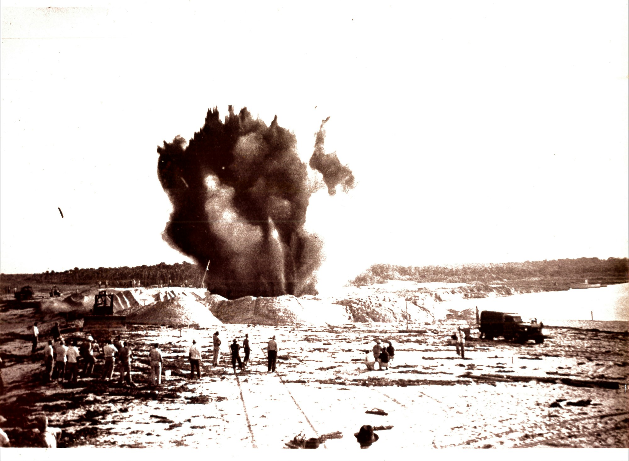
1947-1948 – While there were temporary openings after the war, none lasted long. Work to open an inlet begins again in 1947. In 1948, using surplus U.S. Navy demolitions left behind, Roy O. Couch, Harry C. Goode, Sr., Jake Brannin and others blasted the inlet open again. It has remained open ever since.
1950’s – Throughout the 1950’s, several maintenance dredging projects were completed to deepen and widen the inlet channel. New construction extended both the north and south jetties.
1962 – A channel dredging project was completed by Hardaway Dredging Company and the inlet’s Sand Trap was excavated to capture sand that would otherwise cause shoaling. This project removed 281,147 cubic yards of sand and rock at a cost of $248,138 according to Sebastian Inlet District archives.
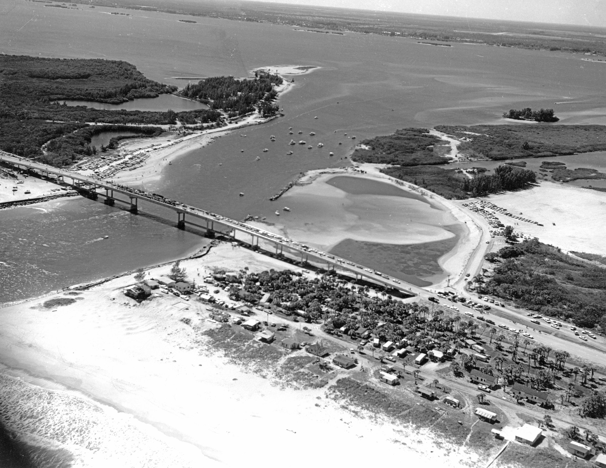
1965 – An event of major significance occurred on February 27, 1965. The bridge that crosses over the Sebastian Inlet was opened connecting A1A from Brevard to Indian River County. In return for helping complete the bridge and pave A1A on the South side, Brevard County ceded almost 3 miles of land South of the inlet to Indian River County. District historical archives include pictures from construction and the opening day ceremony. In several photos, you can see shadows in the lower right-hand corner of two military aircraft that participated in a fly-over during the official ceremony.
1968-1969 – Work begins on another major project, a complete overhaul and 500-foot extension of the North Jetty by Cleary Brothers Construction Co. from West Palm Beach to incorporate the crib structure seen present day. This project was immediately followed by an extension and concrete cap for the South Jetty by Conrad Weihnacht Construction Co. as recommended by the Sebastian Inlet District’s engineer of record, Beindorf & Associates from Vero Beach. Work would extend into 1970.
1970 – Jack Forte’s Crow’s Nest, a well-known fish camp located by the North Jetty, was an institution at Sebastian Inlet for many years. Forte would become an outspoken advocate for local fisherman in a clash that erupted as an unintended consequence of the North Jetty extension. The jetty extension created what some argue was one of the best waves on the East Coast, dubbed “First Peak” by the surfing community. It would produce world-class champion surfers in the 1970s, 1980s, 1990s. Surfers like Matt Kechele, the world-renowned Kelly Slater and many others. For months, fisherman and surfers clashed until signing a peace pact in April 1970, and in reality, the feud between the two groups continued.
1971 – Sebastian Inlet State Park is established after the State of Florida acquires the land surrounding the inlet the year prior. It consistently ranks as one of the most visited parks in the entire state present day.
1972 – The sand trap was deepened and the accumulated sand is dredged. 420,000 cubic yards of sand was placed on downdrift beaches to counter erosion. The new sand trap is 32-acres and the entire project was completed for a cost of $195,998.
1978 – 286,500 cubic yards of sand and rock are excavated from the sand trap and 187,600 cubic yards of sand are placed on downdrift beaches with the remaining rock deposited in the south point spoil area, known today as Coconut Point.
1982 - Florida State Senate Bill 470 (SB470) becomes effective on July 1, 1982 after being signed by the Governor. The bill amends the Sebastian Inlet District’s charter, bringing the total number of Commissioners to five by adding two seats. In November 1982, those seats appeared on the ballot during the general election and two new Commissioners were sworn in that December.
1980’s – Historical records document some tumultuous times in the mid-1980s. Several lawsuits were filed against the District, relationships with the State agency responsible for managing Sebastian Inlet State Park – the Department of Natural Resources – was strained over a dispute on easements and park expansion plans. Legislative delegations discussed redrawing the District’s boundaries to include more of Indian River County and whether Park entry fees should be instituted, followed by discussions on abolishing the District and handing over operations of the inlet to either the Brevard County or Indian River County Commissions.
Resignations left several seats open and an almost entirely new Commission would be elected and appointed by September 1987, when Governor Bob Martinez appointed Charles W. Sembler II to fill a vacancy on the Sebastian Inlet District Commission. Sembler was 5th generation of a commercial fishing family with deep roots in the town of Sebastian. His great grandfather and namesake had worked with Roy O. Couch in 1918 to work the dredge in opening a “cut”. Sembler joined Commissioners Michael Ballard, David Howell, Carol Senne, Bob Ryon on the governing board. The first professional administrator, Raymond LeRoux, was hired by the District, and both survey and biological monitoring protocols were established to better understand the dynamics of the inlet system. A series of reforms instituted by the Commission, along with new legal counsel and accounting firm, help to reestablish the District’s reputation.
A comprehensive master management plan was adopted, the first of its kind in the State to include a commitment to natural resource preservation and environmental protection, ultimately earning the District state-wide recognition. A new set of permanent channel markers was installed and several maintenance dredging projects moved 200,000 cubic yards of sand to the southern beaches. The sand is stockpiled on Coconut Point and truck hauled to the beach.
In 1988, the District competed for a portion of $1million of state funds available for sand transfer and was awarded $776,000. This event signals the start of what remains an active focus for the Commission today, qualifying for Florida State Department of Environmental Protection (FDEP) cost-share funds to complete beach renourishment projects.
1990’s – Four maintenance dredging projects completed in this decade take sand from the inlet’s sand trap and channel, and place more than 800,000 cubic yards of beach quality sand on downdrift beaches. Throughout the 1990s, the Sebastian Inlet District forged partnerships with academic institutions, working with teams from the University of Florida, Florida Atlantic University, Virginia Polytechnic and Florida Institute of Technology (FIT) to conduct what would become the first of many scientific studies. FIT’s first project was biological and physical monitoring of reefs, grass beds and fishing populations, while also collecting data on turbidity conditions near the inlet. Virginia Polytechnic conducted a two-year study on the effects of beach renourishment of sea turtle hatchling success. This is in addition to engineering assessments of the jetties, and geotechnical evaluation of the sand trap and shoals conducted by the District
1993 – Florida Institute of Technology’s Dr. Gary Zarillo installed the submerged wave gauge at Sebastian Inlet. It is an acoustic doppler current profiler with 4 sensor heads to measure water pressure, elevation and velocity to determine speed and direction. Dr. Zarillo is one of the world’s leading coastal modeling scientists and continues to work with the District today to collect and analyze data that help us manage sand resources within the inlet system.
1995 - In August, a 10-year period marred by litigation began when 58 property owners filed suit against the District for loss of beachfront property due to erosion. This complaint of inverse condemnation generated a significant expense for legal representation and expert depositions for the District. Over the next eight years, all but 16 plaintiffs dropped out before a bench trial was held in the 19th Judicial Circuit Court in Indian River County. The court found that only three plaintiffs had established a claim of permanent taking of real property. A jury awarded the plaintiffs, $776,258, $250,000 and $1,200 respectively for lost property. Mediated settlement agreements took place in 2004 and with an entirely new Board of Commissioners. This period of litigation framed the new Board of Commissioners’ approach to inlet management and scientific data collection. The Board would forge a partnership with Florida Institute of Technology's Ocean Engineering & Marine Sciences Department to monitor and manage sand resources at Sebastian Inlet. Today, no other inlet in Florida has collected as much scientific data as the Sebastian Inlet with a focus on science behind inlet management.
1997 - Florida Institute of Technology's Drs. Lee Harris, George Maul and Bart Winder install the meteorlogical and wave station at the tip of the North Jetty to collect data and provide real-time weather data for public access via the FIT Division of Marine and Environmental Systems department.
2002 – In March, a major North Jetty renovation and extension is underway, adding an elevated concrete cap, handrails and a grate system. It would be reopened in August the following year. By November, the Sebastian Inlet District completes a multi-year five-phase beach renourishment that places more than 200,000 cubic yards of sand from an upland source on beaches to the South of Sebastian Inlet.
2004 – Hurricane Frances made landfall on Hutchinson Island on September 5, and less than three weeks later on September 25, Hurricane Jeanne made landfall in almost exactly the same spot as a strong Category 3 storm. Both jetties survived the storms that devastated our area due in large part to the 2002 renovation.
Several days before Hurricane Frances, Martin Smithson, the second Administrator in the District’s history would officially assume his position and four new Commissioners are seated that November. Together, they would chart a new course and accomplish many notable milestones in the next 15 years.
2007 – In addition to placing 86,000 cubic yards of sand on downdrift beaches funded by FEMA to repair hurricane damage and through an interlocal agreement with Indian River County, there were numerous milestones in 2007:
♦ Permanent piling markers are placed in the inlet’s throat section to better define the channel and manatee slow speed zones.
♦ The popular webcam and weather station are installed on the North Jetty, featuring live-feed images and video, current weather conditions, tide charts and more.
♦ The District enters into a master agreement for coastal modeling work with Florida Institute of Technology and Dr. Gary Zarillo publishes the first State of the Inlet report analyzing data from the fixed wave and current gauges to monitor seasonal sea level changes, sediment transport and accumulation within the inlet system focused on managing sand resources in the Sebastian Inlet area.
♦ After decades of unsuccessful attempts, the Sebastian Inlet District finally receives the needed state and federal permits to create a 3,120-foot channel connecting the inlet to the Intracoastal Waterway. Dredging begins in 2007 and navigation markers still maintained by the District today are installed in 2008. The economic and environmental impacts of this 9-foot deep, 150-foot wide channel were significant. Marinas and the local marine industry benefitted from a channel that could now accommodate larger vessels, and in just four years, marine biologists documented a dramatic reduction in prop scars from boaters to the important seagrass beds on the flood shoal West of the inlet because there was now a marked channel. As part of the project, the District also repaired prop scars, installed “Caution. Shallow Water. Seagrass Area.” signs around 145 acres of seagrass habitat in 6 zones. For its work in protecting these seagrass beds, the Sebastian Inlet District Administrator Martin Smithson would receive special awards from the Barrier Island Coalition, Pelican Island Audubon, Friends of the St. Sebastian River and Citizens for Florida Waterways.
2010-2011 – In 2010, the Sebastian Inlet District partnered with Indian River County on a major beach renourishment project that placed 267,182 cubic yards of sand from upland sand mines. That same year and in partnership with the Florida Department of Environmental Protection (FDEP), the District started work to restore the popular tide pool and construct the Dredged Management Material Area, or DMMA. The 6-acre DMMA would allow the District to stockpile 30,000+ cubic yards of sand for immediate emergency dune and beach repair. That project was completed in 2011 with a 50% cost share from FDEP. Total project cost: $749,461. Stockpiling sand would prove extremely important several years later post-Hurricane Sandy (2012) and Hurricane Matthew (2016).
2011 – The Sebastian Inlet District secures a total of $173,000 cost-share funding from Florida Inland Navigation District (FIND) to complete two projects; construction of a new dock and Coconut Point restoration. Built to replace the old, failing L-dock, once known as Henry’s dock, the new T-shaped dock was triple the size. Construction to stabilize the tip of Coconut Point that had lost more than 200 feet in five years to wind-related erosion was completed in 2012.
2012 – The Sebastian Inlet District dredges its sand trap, extracting 122,000 cubic yards of beach quality sand for placement on southern beaches (denoted by FDEP R-monuments - R-4 to R-9) and storage in the DMMA. On October 26, 2012, the eye of Hurricane Sandy passed within 200 miles of Sebastian Inlet with waves peaking at 30 feet offshore and 10-foot breaking waves onshore that caused serious dune erosion. Sand from the District’s DMMA was available for immediate mobilization and was used for emergency dune repair after the storm. The District emptied 16,614 cubic yards of sand from its DMMA and placed 18,000 cubic yards of sand from an upland sand source for a total of 34,614 cubic yards of beach quality sand to repair the dune erosion between beach markers R-8 to R-17. The project was completed by the end of February 2013.
2013 – Cardno ENTRIX economists were commissioned to evaluate the regional economic benefits of Sebastian Inlet. Findings show that:
♦ $93 million in business revenue is generated per year for regional businesses
♦ $48 million in annual income is created for regional businesses and residents
♦ 970 local jobs supported
♦ Almost $8 million is generated each year in state and local tax revenues and fees
All told, when considering the impact on regional property values, the annaul economic impact of Sebastian Inlet was estimated at $200M.
2014 – From 2004-2014, the Sebastian Inlet District Commission lowered the millage rate by 68% and had secured more than $8 million in cost share funding for a host of projects. In 2014, Orion Marine Group is awarded the bid for the sand trap dredging, excavation and expansion project. More than 111,000 cubic yards of sand is placed on downdrift beaches and 50,000 cubic yards of coquina rock and sand were dredged from the bottom to increase capacity and create a more uniform, now 42-acre sand trap. The newly expanded and deepened depression within the inlet system would now take longer to fill, extending the timeframe for periodic dredging, sand bypass and beach renourishment projects to 4-5 years.
2018-2019 – The Sebastian Inlet District completed a sand trap dredging, channel maintenance and beach renourishment project. Phase I dredged the inlet's 42-acre sand trap, placing 113,000 cubic yards of sand on downdowndrift beaches per a beach fill template designed by coastal engineers. Sand was placed on a 1½ mile stretch of beach starting at McLarty Treasure Museum and continuing South past the Ambersand beach access, and designated by Florida Department of Environmental Protection (FDEP) R-monuments R-10 to R-17.
Phase II of the project dredged the 3,120-foot channel connecting the inlet to the Intracoastal Waterway. The channel was dredged to 150-feet wide and to varying depths of up to -12 feet to aid in navigation. More than 50,000 cubic yards of sand have been stockpiled in the District’s Dredged Material Management Area (DMMA) for future emergency beach fill and dune repair.
Total project cost was approximately $3M and 75% of the project was covered by FDEP cost-share funding.
The District continue to work closely with officials at FDEP and the Army Corps of Engineers to obtain needed permits and conduct important environmental monitoring that takes place pre-, during and post-project. During the project, ongoing turbidity monitoring was conducted around the dredge and at the ocean side discharge point by Florida Institute of Technology to meet standards set by FDEP to protect seagrass shoals to the West of the inlet and nearshore hardbottom along the southern beaches. Sea turtle and shore bird monitoring within the project area was conducted by Ecological Associates, Inc. (EAI) for the entire 2019 nesting season to ensure no impacts, including escarpments or changes in the profile of the beaches after grading. Marine biologists from CSA Ocean Sciences, who conducted a comprehensive, pre-project nearshore hardbottom survey in August of 2018, completed a post-project survey to ensure no sand has migrated to cover the important nearshore hardbottom habitat South of the inlet, and biologists from Atkins North America conducted field work in August to monitor seagrass beds in six zones on the flood shoal West of the inlet.
January 2019 - The District named coastal engineer James Gray, Jr., as the third professional administrator in the organization’s history.
May 23, 2019 - The Sebastian Inlet District marked its 100th Anniversary and celebrated the milestone with a series of events and outreach programs. However, a large community event planned for September was cancelled due to the arrival of Hurricane Dorian.
May 2022 - Hurricanes Mathew (2016) and Dorian (2019) eroded portions of the north and south shorelines along the Sebastian Inlet Channel. On May 11, 2019, the District embarked on a project to armor the shorelines on both sides of the inlet channel.. The contractor rehabilitated approximately 655 feet of shoreline along the North Shore of Sebastian Inlet. The work included covering a relic steel seawall near the tide pool with limestone rip rap. At the South shoreline, covered bare areas with limestone rock.. Repairs include the catwalk under the State Road A1A Bridge west to the T-Dock. The project was completed on October 21, 2022. Ad valorem taxes funded the $1.1 million project.
January 2023 - The District embarks on a beach sand placement project spanning 1.5 miles between the area of the McLarty Treasure Museum and an area 1,500 south of Ambersand Beach. The two-month-long project added about 30,000 cubic yards of sand (or about 1,760 dump truck loads) to the site. The project was not a response to Hurricanes Nicole nor Ian in 2022, but rather bypass sand as required in the Florida Beach & Shore Preservation Act.

November 2024 - The District launches the North Jetty Revetment Improvements Project – Phase 1, rehabilitating approximately 210 linear feet of revetment structure with four-foot diameter granite and constructing a steel, sheet pile seawall with concrete sidewalk deck along portions of the Sebastian Inlet north jetty that were impacted by storms. The $2.5 million project reopened on June 30, 2025, ahead of schedule.
Fall 2024- Spring 2026 - The District embarked on a Truck Haul and Beach Placement Project in the fall of 2024, placing approximately 135,000 cubic yards of sand on the south beaches by April 2025. The project was incomplete by the time sea turtle nesting season arrived. The contractor, ATL, remobilized in November 2025 and must dredge an additional 130,000 cubic yards of sand from the inlet channel and sand trap and place it on the beaches south of the inlet. Additionally, approximately 40,000 cubic yards of sand will be placed in the District’s Dredged Materials Management Area (DMMA) on the north side of the inlet.

.JPG?ixlib=rb-1.1.0&or=0&w=720&h=720&fit=max&auto=format%2Ccompress&s=7f962f1c965419e095cdcad85a27f1e9)
