
Biologists complete annual field work and monitoring of seagrasses at Sebastian Inlet
Our partners at Atkins North America recently completed their field work as part of the Sebastian Inlet District’s ongoing annual biological monitoring of seagrass beds on the western flood shoal at Sebastian Inlet. One immediate observation and hugely positive trend – no new boat propeller scars were identified on the protected shoals this year. “Prop scars” are one of the single most preventable threats to the health of this important habitat.
This biological monitoring dates back to the District’s 2007 channel extension project to connect the Intracoastal Waterway (ICW) to Sebastian Inlet with a 3,120-foot marked channel for boaters and was part of a comprehensive mitigation strategy to protect sensitive seagrass habitat.
Per a five-year (2008-2012) seagrass mitigation and monitoring program and pursuant to permits issued by the U.S. Army Corps of Engineers (USACE) and the Florida Department of Environmental Protection (FDEP), the District:
- Conducted a biological survey to identify 6 protective zones (A-F) on the western flood shoal.
- Placed “Caution, Shallow Water, Seagrass Area” signs clearly delineating 145 acres of seagrass beds in those 6 established zones on the flood tidal shoal.
- Worked with a team of marine biologists to recover 459 seagrass planting units from the proposed channel alignment for re-planting in designated areas.
- As part of the survey, 41 propeller scars were identified including 22 significant “blow-out” features. Seagrass harvested was re-planted here and the District successfully deployed 2,031 Sediment Tubes® to repair the worst prop scars.
- Provided $750,000 in financial support needed to install the Indian River County Main Relief Canal Pollution Control Structure. The structure came online in July 2008.
- Established monitoring protocol utilized by St. John’s River Water Management District (SJRWMD) and an annual timeline of field work and analysis to be conducted by the District. The data collected each year is shared with the SJRWMD and helps provide a complete picture of seagrass habitat in the IRL.
- Published and continues to distribute a Sebastian Inlet Navigation Guide. These are free to the public and a downloadable version can be found HERE.
“The Commission has made an ongoing commitment to protect this sensitive habitat, opting to continue annual biological monitoring beyond the 2012 permit-required mitigation plan, and we share the important data sets collected with partners working to identify lagoon-wide trends of seagrass in the Indian River Lagoon as an important natural resource,” said James Gray, Sebastian Inlet District Executive Director.
MONITORING TRENDS
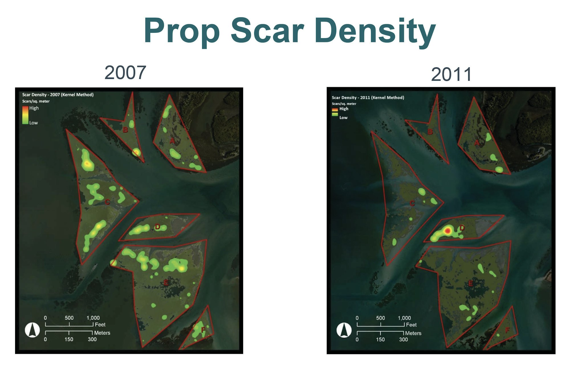
From 2007-2011, with a marked channel for boaters to access the inlet and caution signs to help them avoid the seagrass beds, marine biologists documented a dramatic year-over-year reduction in prop scar densities shown as shown in this graphic.
In 2011-2012, there was a massive seagrass die off lagoon-wide that had a prolonged impact on the health of the seagrass beds on the western flood shoal.
By 2018, marine biologists documented a resurgence of Johnson’s seagrass, a federally-listed threatened species. First identified in only 2 of the 6 zones in 2007, by 2018, Johnson’s seagrass was in all 6 zones along with Shoal Grass and Manatee Grass. Johnson’s seagrass has been significant in the recovery of all seagrasses on the flood tidal shoal because its root system helps stabilize the shoal as seagrasses recolonize.
In 2019, marine biologists document a cumulative gain of 7.86 acres of seagrass on the flood tidal shoal. Six different species of seagrasses found in the Indian River Lagoon were identified in Zones A-F. For more detailed data from the most recent analysis published after the 2019 biological monitoring, visit HERE.
Marine scientists will coalesce the data collected during the 2020 field work and anticipate submitting a detailed analysis and report later this year. District officials will publish the report for the public once complete.
About the Sebastian Inlet District
The Sebastian Inlet District was created in 1919 as an independent special taxing district by act of the Florida State Legislature, and chartered to maintain the navigational channel between the Atlantic Ocean and the Indian River. The Sebastian Inlet District’s responsibilities include state mandated sand bypassing, erosion control, environmental protection and public safety. The Sebastian Inlet supports a rich and diverse ecological environment that is unparalleled in North America. The Inlet is vital not only to the ecological health of the Indian River Lagoon, but it is also an important economic engine for local communities in the region. Known as the premier surfing, fishing, boating and recreational area on the east coast of Florida, the inlet is one of only five navigable channels that connect the Indian River lagoon to the Atlantic Ocean.
Posted: 9/22/2020